Latest News
- Canada Life denies amputation coverage to RCMP officer injured in line of duty; activists say he's not alone
- Ontario's provincial plan for 2025 is fully completed.
- Rare adoption of a polar bear cub near Churchill confirmed by scientists
- Alberta closes supervised drug use centre at Edmonton hospital
- These maps show how the pre-Christmas storm is sweeping across Canada
Latest Ads
-
Jasmine Jewel
Call

-
Omidan group
Call

-
Amir Madanpour
Call

-
Dimo studio
Call

-
Yorkacademy
Call

-
Maryambagheri
Call

-
Shishlix Restaurant
Call


 164 View
 207 View
 1078 View
 176 View
 247 View
 122 View
 570 View
 199 View
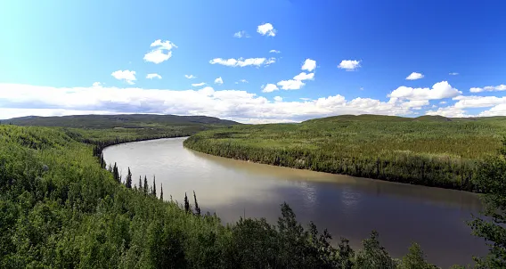
Lowering the water level of Canada's longest river
The water level of the Mackenzie River, Canada's longest river, has dropped to an unprecedented level, surprising the communities that rely on it and the indigenous people.
The Mackenzie River is 1,738 km long from Great Slieve Lake to the Beaufort Sea, and its watershed covers parts of five provinces and territories.
According to the government of the Northwest Territories, the amount of water flow in most places along the river is either much lower than the average or at the lowest value recorded at this time of the year. Experts say that the water level is about two meters below the average level. and the typical seasonal changes are about 50 cm. Two meters below normal is significant because two years ago Mackenzie's rivers and lakes were at their highest.
This dehydration is not limited to Mackenzie. Great Bear and Great Slave lakes are at or near their lowest levels, as are smaller rivers that drain into the Mackenzie.
According to the people of this region, in the last two years, they have experienced severe drought with very high temperatures in the entire Mackenzie River region, which is definitely a sign of climate change.
news source
Suggested Content
Latest Blog


Login first to rate.
Express your opinion
Login first to submit a comment.
No comments yet.