Latest News
- Meta has discontinued the Messenger desktop app.
- What we know about Nick Reiner, son of Rob and Michelle Reiner
- Google's Dark Web Report is being removed; what users need to know
- Tenants consider leaving Newfoundland after no-fault eviction; 'Our lives turned upside down'
- Toronto man beats new Finch LRT train on foot; arrives 18 minutes early
Latest Ads
-
Jasmine Jewel
Call

-
Omidan group
Call

-
Amir Madanpour
Call

-
Dimo studio
Call

-
Yorkacademy
Call

-
Maryambagheri
Call

-
Shishlix Restaurant
Call


 159 View
 823 View
 810 View
 176 View
 442 View
 220 View
 271 View
 237 View
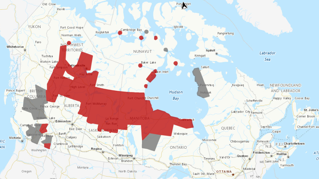
Temperatures will reach 30 C in some Canadian provinces. Here's where
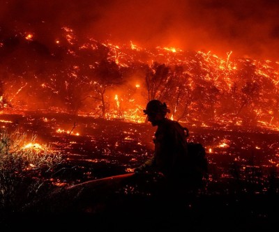
The week ahead will bring a mix of thunderstorms, heat warnings and air pollution warnings for some Canadian provinces as summer weather and wildfires continue.
Here's a look at this week's weather forecast:
intense heat
Five provinces and two territories are under heat warnings this week.
For northern Alberta, including Mackenzie and Wood Buffalo counties, a heat warning says warm daytime temperatures near 30 degrees will continue into early next week, according to CTV morning meteorologist Kelsey McEwen.
Environment Canada said temperatures will drop on Wednesday.
Some areas in British Columbia, Manitoba and Saskatchewan are also expected to have similar temperatures.
A heat warning has also been issued across the territories, including Fort Simpson and Hay River in the Northwest Territories. Forecasts indicate that the hot temperature will vary between 29 and 35 degrees Celsius during the day. Temperatures will drop on Tuesday, the Met Office of Canada said.
In areas like Arviat and Baker Lake in Nunavut, daytime temperatures will reach the mid to late 20s to early 30s Monday through Tuesday.
Environment Canada has issued a heat warning for areas of Nunavut that a cold front passing through Tuesday night into Wednesday will bring daily maximum temperatures back to seasonal levels Wednesday afternoon.
Poor air quality
Air quality warnings are in place in areas that are also under heat warnings, McEwen said.
Warnings for areas in northern Alberta, Saskatchewan and Manitoba indicate that smoke from the wildfires is causing or likely to cause very poor air quality and reduced visibility.
These alerts also warn that air quality can vary over short periods of time and from hour to hour.
In British Columbia, various areas across the province — including Fort Nelson, Whistler and Fraser Canyon — are under special air quality statements, McEwen said.
Environment Canada said in a statement that the Northwest Territories fires will have a "significant" impact in southern, central and northeastern British Columbia over the next 24 to 48 hours.
Areas in the N.W.T. and Nunavut that are under heat warnings are also under air quality warnings.
In northern Ontario and Quebec, smog is the main cause of poor air quality over the next few days.
A statement from Environment Canada warned: "Smoke from wildfires in the northern prairies and northern Ontario moving into northwestern Ontario has led to worsening air quality."
storm
A moderate risk of thunderstorms is expected in southern Alberta Monday afternoon, with the possibility of hail and gusty winds, McEwen said.
McEwen added that a slight risk of storms is expected across Alberta and parts of Saskatchewan.
According to McEwen, there is a high risk of severe storms making landfall in the Okanagan, British Columbia, with strong winds and torrential rain.
"We're looking at a possible tropical storm number 5 that's just off the Windward Islands in the Caribbean," McEwen said in Monday's forecast.
These islands include Antigua and Barbuda, Saint Kitts and Nevis, and Saint Martin.
McEwen said Ernesto will be the third storm of the year and will move to the west of the region.
news source
Suggested Content
Latest Blog


Login first to rate.
Express your opinion
Login first to submit a comment.
No comments yet.